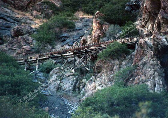
One of the Granite Flume trestles in lower Big Cottonwood Canyon -
c.1997 / Donald K. Winegar - Tintic Images
Brief history
The Granite Flume trail is actually three separate trails,
upper, middle, and lower, each following the path of the old Utah Power Company water flume (also known as the Granite flume),
but now divided by sheer drops and wide spans in the rock outcroppings that were once bridged by the flume.
The path of the old flume runs on a gradual slope from just below the Stairs power plant
(about two miles up Big Cottonwood Canyon), to the mouth of the canyon along the north side.
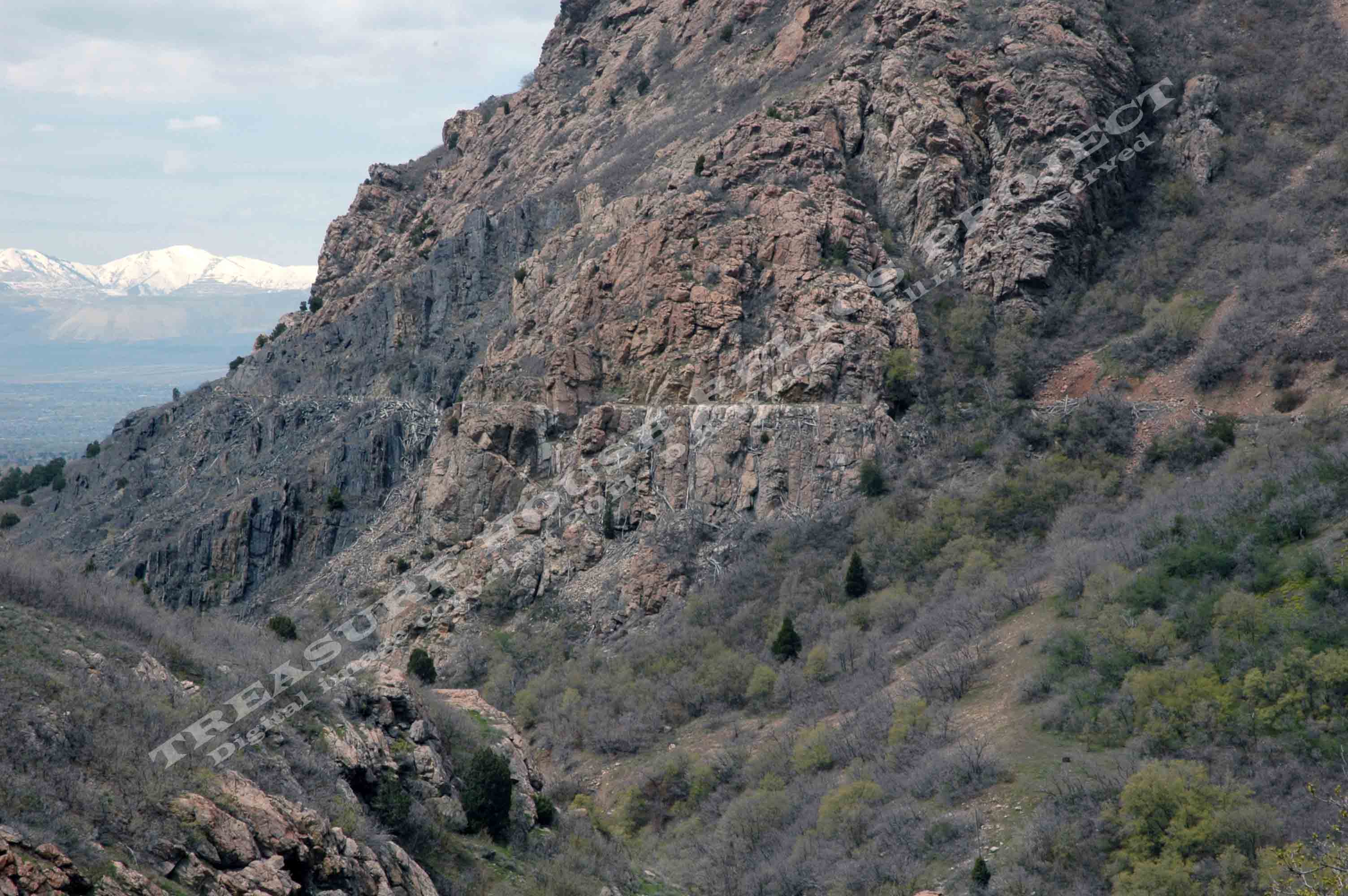
Red line on the image above shows the original path of the Granite
Flume. Portions of the path now make up the Granite Flume trails. Map created using Google Earth - Copyright 2011 Google - Click on image for a larger view.
The original flume took water in from the tailrace or outflow at the Stairs plant, carried that water down-canyon
to a penstock that directly fed the Pelton wheel generators at Granite plant. Thus, the same water used to generate power
at two separate locations. The flume was roughly 1.5 miles long, passed over nine trestles, and through one tunnel.(1)
During
it's lifetime, the flume served it's original builders and subsequent owners well. That's not to say it didn't have issues.
More than once, a segment of the flume would would fail, releasing free-flowing water to cascade down carrying rocks, dirt,
and debris with it. Carving out a section of the hillside only to deposit the the material on the road or the creek bed far
below.(2)
It was not uncommon for small flows of water to escape the flume all along it's length. Though the drips and
trickles were of no consequence in the summer months, in the winter, these small flows would create massive icicles that would
hang from the bridgework and trestles. Sometimes dozens to over a hundred feet in length.(3)
The original flume, built in 1896 and constructed of wood, was rebuilt
and repaired a number of times over its 100+ year history. In 1998 it was replaced entirely by an underground metal pipeline,
a small portion of which followed the original flume path. Once by-passed, the old flume was dismantled. Most of the lumber
and metal being salvaged. Most that is, but not all. (More about that later.)
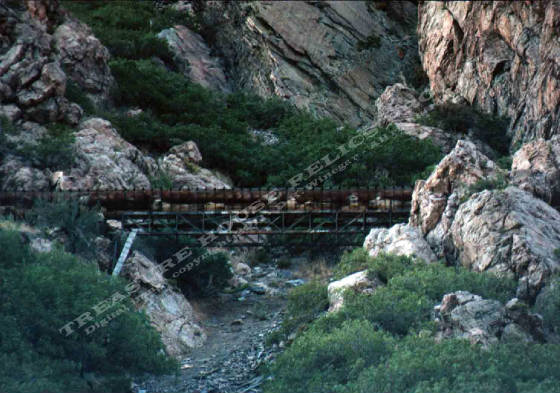
Another span along the Granite Flume - c.1997 / Donald
K. Winegar - Tintic Images
Getting there (Three trailheads)
There are at least three ways to access the upper portion of the old
Granite Flumeway trail.
First, the
gated access road below the Stairs power plant and opposite the Birches picnic area. This one I call and have labeled "Upper Granite Flume Trailhead".
Second, the old "Upper Smoots Dugway", opposite and just above the Ledgemere
picnic area. I call and have labeled this one "Ledgemere Trailhead".
Third, the "Lower Smoots Dugway", on the north side of the road at
the sharp bend just below the Ledgemere, and just above the Oak Ridge picnic areas. I call and have labeled this one "Oak Ridge Trailhead".
Specific details about each are given below.
Map created using Google Earth - Copyright 2011 - Google - Click on image for a larger view.
Upper Granite Flume Trailhead
|
Approx. G.P.S. Location:
|
40.37.390 N - 111.45.383 W (field) |
|
|
Approx. Elevation:
|
5433' (field)
|
|
|
30 x 60 Minute Map:
|
Salt Lake City, Utah
|
|
|
7.5 Minute Map:
|
Draper, Utah
|
|
The upper trailhead begins at the steep gated access road just below
the Stairs power plant and opposite the Birchs picnic area. Though initially steep, it is only that way for 30 or 40 yards,
then quickly levels off. Once you reach the level ground you are standing on top of the now buried new pipeline, and where
the bed of the old flumeway used to be.
While
the trail seems to be level, in reality it has a very gradual, almost imperceptible downhill slope. This upper trailhead is
the easiest way to access the old flumeway trail, and allows the longest walking/hiking opportunity, about 3/4 of a mile one-way.
Just because it is relatively flat, does not mean it does not present
a hazard. The trail in this first section is littered with boulders of all sizes. The trail makes its way through the rocks,
but they are a tripping hazard. In addition, in some places, there are sheer drops right at the trailside. While it can be
a good family hike for older children, it is not a place to to take small children and just turn them loose. Pay attention
and use caution.
The trail is open and exposed at first
where the new water line was installed, but then it moves into a shallow cut with trees and brush on both sides where the
new line leaves the old flumeway path. For the most part, it will remain in the trees all the way to the first gap. The first
of many gaps that were once spanned by trestles and bridges.
To
go beyond this first small gap is OK, and for the most part safe. There is still a distance of flat and level hiking that
can be done on the other side, but caution must be used in crossing. Old timbers and cement footings are present, as well
as a rock filled gulch down hill form the crossing point. If you decide to go past the first gap, under no circumstances should
you try to go past the second gap!
WARNING! Going beyond the second gap is not advisable, nor is it safe. I cannot use strong enough language to make this
point. The danger is great, so too the exposure. Sheer cliffs, rock overhangs, and narrow ledges are common beyond this point,
in what I call the middle section of the old flumeway path. This area should be avoided at all costs. There are no mines or
reasons to tempt fate by exploring this dangerous area.
The
dangerous middle section of the trail is outlined in black on the first and second Google earth images above.
As shown on the images, access to the Purple Shale and Ledgemere mine sites is made by way
of this upper flume trail section, not the middle section.
Ledgemere Trailhead (to the Upper
Granite Flume Trail)
|
Approx. G.P.S. Location:
|
40.37.422 N - 111.45.754 W (field) |
|
|
Approx. Elevation:
|
5334' (field)
|
|
|
30 x 60 Minute Map:
|
Salt Lake City, Utah
|
|
|
7.5 Minute Map:
|
Draper, Utah
|
|
The Ledgemere Trailhead is located near the top of the large parking area across the canyon highway from the
Ledgemere picnic area. The trail begins on broken pavement of the upper portion of the old "Smoot Dugway"(4), a short by-pass segment of the original paved highway.
The trail follows the old road and the contours of the hillside before turning north and
climbing quickly into the trees. Shortly, the trail breaks to a clearing where it crosses over the Oak Ridge trail coming
up from the left, and continuing up to the right. While you can turn right and follow the Oak Ridge trail up to the flume
trail, for now, just keep going straight.
After crossing, the trail you are on becomes
steeper, climbing rapidly, and soon you are back in the trees. A short distance further and you will will come to flat shaded
area with a stone fire ring. This is not the flumeway trail, but you are close. You must keep going up the hillside to a second
flat area. It's not far, and when you get there, you'll know it. Concrete pads will be visible to your left and right.
At
this point you are roughly in the middle of the upper flumeway trail, (see Image) You can go either direction and begin exploring.
Left will take you to the Ledgemere Mine trail, the first cut, the second cut, and the west end of the upper flumeway trail.
To the right are the Purple Shale Mines trail, the Oak Ridge trail connection point, and eventually the upper Granite Flume
trailhead back at the canyon highway. (Not where you started from but the Upper trailhead.)
Oak Ridge Trailhead (to the Upper
Granite Flume Trail)
|
Approx. G.P.S. Location:
|
40.37.465 N - 111.46.046 W (topo) |
|
|
Approx. Elevation:
|
5433' (field)
|
|
|
30 x 60 Minute Map:
|
Salt Lake City, Utah
|
|
|
7.5 Minute Map:
|
Draper, Utah
|
|
The Oak Ridge trailhead (as I call it), begins at
the sharp turn above the Oak Ridge, and below the Ledgemere picnic areas, on the north side of the Big Cottonwood Canyon Highway.
The trail follows the lower portion of the old "Smoot
Dugway" by-pass, which is also the route of the new underground metal piping that replaced the old Granite flume. The
trail climbs steadily up and to the east, almost due east. Soon it leaves the old highway route and eventually crosses over
what I call the Ledgemere trail. You can turn to the left and follow the Ledgemere trail, but for now, just keep going straight.
This trail follows the route of the new underground
pipeline and eventually reaches the old flumeway path where it levels off. From there you can go right and hike to the upper
flumeway trailhead, or turn to the left and head for the Purple Shale Mines trail, Ledgemere trail connection point, Ledgemere
Mine trail, and the cut that marks the west end of the upper Granite Flume trail.
View of the dangerous, rocky middle section of the flumeway path as
seen from the upper portion of the flumeway trail. - c.2011 / Donald K. Winegar - Tintic Images
What remains
To this day, all along the path of the old flume-way, cut
lumber of various shapes and sizes can be seen. Most of it on the down-hill slopes below the flume trail, some above, and
some on the trail path itself.
Less frequent along the trail are the
are the large "U" shaped metal bands that formed and gave shape to the flume. Rusted, and in some cases twisted,
a few of the metal bands are still fitted with long bolts that were also key to shaping and securing the flume.
By far, the most rock-solid evidence of the old waterway, even more than the scattered lumber
debris, are the many concrete foundations that once supported the flume. Hundreds of them are there, still in place and running
almost the entire length of the old trail. Some, just flat square pads, mostly in the upper portion, but just as many pad
and pier shaped foundations in the lower section.
Note: Dozens
of the lower piers are still enclosed by the cut wooden forms made to hold the concrete in place as the piers dried. (See "Lower Granite Flume Trail" page
of this site.)
It
is easy to spot the locations where the flume trestles once stood. Large to small, trestles of all sizes spanned gaps of all
sizes, Some of these gaps can be crossed over today with effort, others, like the one pictured above are simply to wide, deep,
and dangerous.