|
Approx. G.P.S. Location:
|
40.35.506 N - 111.47.258 W (topo) |
|
|
Approx. Elevation:
|
5355' (topo)
|
|
|
30 x 60 Minute Map:
|
Salt Lake City, Utah
|
|
|
7.5 Minute Map:
|
Draper, Utah
|
|
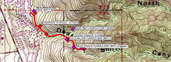
Brief history
Deaf Smith Canyon is located in the foothills of the Wasatch
Front just north of the mouth of Little Cottonwood Canyon. Though a number of smaller operations were known in the canyon,
The Gold Willow Group and the Utah-Mammoth group are the operations responsible for most of the workings and various dumps
that are found in the canyon.
Getting there
From Wasatch Blvd. turn east into
the Golden Hills Sub-division on Golden Hills Ave. at 8785 South. Drive east to Kings Hill Drive (3710 East) and turn left.
Travel North on Kings Hill Drive to Golden Oaks Drive (8620 South) and turn right.
Golden Oaks
Drive is a dead end street. Drive to the top of the street and park. The first part of the trail to Deaf Smith Canyon begins
here. A steel cable blocks the road. Just beyond that steel cable a dirt road turns south. Follow that road south until it intersects a narrow private
driveway. Turn left (East) and follow the driveway past the house (and private property to the south) to a point where the
pavement ends. The trail into the canyon and the mining area continues here.
| TOPO! COPYRIGHT 2010 NATIONAL GEOGRAPHIC |
|
Map
created using TOPO! mapping software from National Geographic.
"TOPO! Copyright 2010 National Geographic"
www.topo.com
What remains
A number of waste rock dumps, a few broken and fallen
structures, and a couple of partially collapsed adits can be found throughout the lower canyon area. The Gold Willow dumps
are the first you will encounter. The Utah Mammoth dump is farther up. No complete structures remain standing anywhere in
this area.
Click on the
links below to view the sites in Deaf Smith Canyon.
