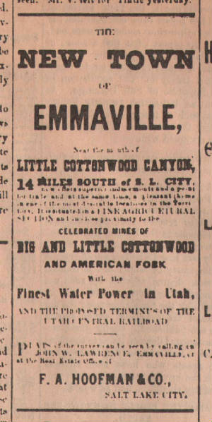
Ad that appeared in the Saturday Morning, April 15th, 1871 edition
of the Salt Lake Daily Tribune promoting the new town of Emmaville - c.1871 THRP - Winegar
Collection - Tintic Images
Location data
QUICK LOCATION PATH: Utah / Salt
Lake County / Big Cottonwood District / Emmaville or Gold City area
|
Approximate GPS Location:
|
40.35.290 N - 111.47.569 W (approx) |
|
|
Approximate Elevation:
|
5133' (approx)
|
|
|
30 x 60 Minute Map:
|
SALT LAKE CITY, UTAH
|
|
|
7.5 Minute Map:
|
DRAPER, UTAH
|
|
Brief history
An informal stopping point on Little Willow Creek for a number of years, the "town"
of Emmaville was begun as a land promotion to take advantage of its strategic location as a mid-point between the boom-town
of Alta and downtown Salt Lake City. Believed named for the famous Emma mine near Alta, even its famous name could not save
the town from becoming another "relic" of Utah's history.
Popular from its start, it was a stopping point for the wagons hauling ore from the mines
of Little Cottonwood, teams transporting granite blocks from the Mormon Temple quarry at Granite, stage-lines, travelers,
and early sight-seers. The town grew quickly and several commercial buildings and homes were constructed in rapid succession.
Premium prices were paid for commercial
and residential building lots that were promoted by F. A. Hoofman and Co., and sold by Agent John W. Lawrence.
Stores, hotels, boarding houses, blacksmith, livery, and of course, 2 saloons,
put Emmaville on the map. Dozens of families, miners, quarrymen, teamsters and more called it home, though many on a strictly
temporary basis. At its height, some 500 people resided there. The town, in the beginning was everything the speculators,
promotors, and agents could hope for.
Newspaper advertisements boasted
that Emmaville was "Situated in a Fine Agricultural Section", "Close Proximity to the Celebrated Mines of Big and Little
Cottonwood and American Fork", "Finest Water Power in Utah", and "The Proposed Terminus of the Utah Central
Railroad".
While
the first three items may have been true, the last was not to be. A railroad did eventually make its way into Little
Cottonwood Canyon. It was not the Utah Central as promoted, but the Wasatch and Jordan Valley. More importantly, it did not
terminate or even pass through Emmaville. It drove further south and east, terminating in the town of Granite, missing Emmaville
by some two miles. Those two miles would prove critical to the future of the town.
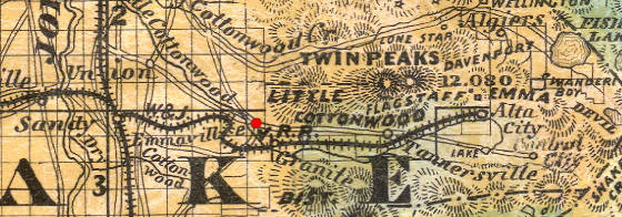
1875 Froieth's Map of Utah shows Emmaville (red dot), Granite, Alta
City, and the then completed Wasatch & Jordan Valley Railroad line THRP - Winegar
Collection - Tintic Images
With completion of the railroad to Granite, growth and prosperity that was hoped for Emmaville shifted to the
new terminus. Though road activity continued, wagon and stage stops shifted to Granite as well. Customers, miners, teamsters,
day-trippers, and passers-by, did just that, passed on by. In time, all of the businesses would close or relocate, and residents
would trickle away. The premium lots abandoned to whomever stayed behind.
Though shown on the 1875 Froiseth map (detail
shown above), the town was already in decline. By then, It had suffered an epidemic, a fire that destroyed
several buildings, and a few years later it would fade completely, becoming little more than a footnote to history. Looking
back, it would probably be little consolation to the one-time residents of Emmaville to know that Granite would suffer the
same fate a short time later when the rail line was advanced to Wasatch and then Alta.
A stone monument placed along Wasatch Blvd. by the Daughters of the Utah Pioneers now marks
the general area of the town.
30 years later
and near the site of Emmaville, another "town" would have a brief life. It would be called "Gold City"
or "Jefferson City". Like Emmaville, it would live and die in relation to fortunes of nearby mining operations.
Getting there
At about 8800 South on Wasatch Blvd., a large stone marker can be found on the east side of the road. This is
the general area of Emmaville.
What remains
Nothing. Only the stone monument marks the approximate location of the old site.
______________________